The Intermicronational Geophysical Year or ImGY is an international scientific effort that will run from July 1st, 2007, to December 31st, 2008. It is modeled on the original International Geophysical Year (IGY), which occurred exactly 50 years ago.
| The Intermicronational Geophysical Year is designed to develop and explore the natural sciences as they pertain to the world's micronations. In essence, the ImGY is designed to encourage micronationalists to explore the physical world around them, away from the computer terminal, and then report on it, with a micronational slant. With the understanding that most micronations lack the resources to undertake major science experiments, the ImGY seeks instead to expand the frontiers of the natural sciences within micronational limits. Categories of investigation may be (but are not limited to) geology, geophysics, soil science, oceanography, glaciology and atmospheric science. In addition, the study of botany and zoology is included. |
 |
 |
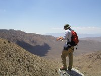
How can you take part? Simply put, represent your micronation in a study of the natural world around you. Explore a nearby park, conduct a simple experiment in weather, document the flora and fauna in your neighborhood, anything along that line, and then report it. Nothing fancy, just do what you can. Your report, preferably with photographs, can be posted on this site, or you can post on a site of your own, providing the link here. As always, it is suggested that your observations and report reflect your micronation, perhaps under the title of your nation's science institute (if you don't have one, create one).
The principal rule is that your observations and report must reflect the real world, not a virtual or imaginary one. Beyond that, a brief summary of your discoveries, preferably with a few photographs, is all that is needed. Submit your report and photos to the address below, and they will be posted free of charge on this site, courtesy of the Republic of Molossia.
|
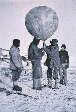
The original International Geophysical Year focused on aurora and airglow, cosmic rays, geomagnetism, gravity, ionospheric physics, longitude and latitude determinations (precision mapping), meteorology, oceanography, seismology and solar activity. IGY activities literally spanned the globe from the North to the South Poles. Although much work was carried out in the arctic and equatorial regions, special attention was given to the Antarctic, where research on ice depths yielded radically new estimates of the earth's total ice content. IGY Antarctic research also contributed to improved meteorological prediction, advances in the theoretical analysis of glaciers, and better understanding of seismological phenomena in the Southern Hemisphere.
Send your comments, suggestions and, above all, scientific reports here.
LINKS:
 Imperial Government of the Imperium of DeWaCo Estates' establishment of Corbett-On-The-Merrill as their headquarters for ImGY the recording of all surveys, experiments, and results of all expeditions by that nation. Imperial Government of the Imperium of DeWaCo Estates' establishment of Corbett-On-The-Merrill as their headquarters for ImGY the recording of all surveys, experiments, and results of all expeditions by that nation.
 The Principality of Kaznia's webpage for the Intermicronational Geophysical Year. The Principality of Kaznia's webpage for the Intermicronational Geophysical Year.
 Observations of a Lizard, Molossia's first project for the Intermicronational Geophysical Year. Observations of a Lizard, Molossia's first project for the Intermicronational Geophysical Year.
 Vikesland Rocket Project, Vikesland's first project for the Intermicronational Geophysical Year. Vikesland Rocket Project, Vikesland's first project for the Intermicronational Geophysical Year.
Sandpiper Island, Molossia's second project for the Intermicronational Geophysical Year.
 El Presidente's Scientific Expedition, the Republic of Greater Waunllech's first project for the Intermicronational Geophysical Year. El Presidente's Scientific Expedition, the Republic of Greater Waunllech's first project for the Intermicronational Geophysical Year.
This site is under construction!
|